


Additional features
-
Night mode
Tashkent’s new master plan goes interactive: Roads, renovations, and conservation explained
An interactive online map of Tashkent’s new master plan has been launched on the website of the Ministry of Construction. But what do the different colors on the map mean? Can residents check whether their homes are marked for demolition? Will city roads be expanded? Kun.uz spoke with Aziz Khudoynazarov, Acting Head of the Tashkent City Construction and Housing & Public Utilities Department, to get answers to these pressing questions.
Can the map identify buildings marked for demolition?
According to Aziz Khudoynazarov, the map does not allow users to see which buildings across the city are slated for demolition. However, it does indicate which properties might fall under future road expansion projects.
On the map, roads are marked in red. In some areas, red lines stretch across spaces where roads currently don’t exist. In other cases, the thickness of the red lines exceeds the current width of certain streets, even overlapping parts of adjacent buildings.
This, Khudoynazarov explains, reflects a long-term vision: the potential expansion of certain streets over the next 45 years to alleviate traffic congestion. However, this is not limited to expanding lanes for vehicles – it also includes space for sidewalks, bicycle paths, green zones, and parking areas.
Many secondary and tertiary roads are currently too narrow to accommodate such infrastructure. In some neighborhoods, buildings are situated dangerously close to roadways, leaving little to no room for laying utility networks.
“These red lines also serve as future corridors for utility systems and make it possible to later build sidewalks, bike paths, and parking areas to improve movement for residents,” said Khudoynazarov.
He emphasized that these potential expansions primarily target secondary and tertiary roads, not major arterial streets.
“We’ve included these planned roads based on population growth forecasts and increased infrastructure demand over the next 45 years. If development follows this master plan, there will naturally be a need for new projects in the future,” he said.
Any decision to expand roads will require separate official documentation, public notification, and legal processes such as compensation – all to be carried out in accordance with Uzbek law.
What do the colors on the map represent?
Khudoynazarov provided a breakdown of the color codes used in the interactive map:
- Light green – Conservation zones: areas designated for kindergartens, schools, hospitals, and sports facilities.
- Dark green – Conservation zones: protected green areas and buffer zones around canals and railways.
- Light pink – Reconstruction zones: residential areas.
- Dark gray – Renovation zones: commercial and entertainment areas (non-residential buildings).
- Light green-yellow – Mixed reconstruction and renovation zones: residential areas.
- Light brown – Reconstruction zones.
- Dark pink – Renovation zones in new development districts such as Sergeli, Yangi Hayot, and New Tashkent.
By clicking on any zone, users can view strategic details such as the type of project, its function, the number of floors allowed, and other planning data.
What are the official definitions?
According to the government resolution that approved the master plan:
Conservation zones
These aim to improve the city's ecological, sanitary, cultural, and social conditions. They include green areas, water protection zones, road buffer zones, and cultural heritage sites. No new residential or non-residential buildings are allowed in these areas.
Reconstruction zones
- These are existing urban areas where redevelopment is allowed by the Tashkent City Administration, based on public input.
- Reconstruction is permitted in places that were completed in the last five years and are already suitable for living.
- In areas that require upgrading, population density is preserved while external appearances are modernized and public spaces improved. New social and infrastructure facilities may also be added.
- In areas needing densification, multi-story buildings may be constructed based on socio-economic needs and infrastructure capacity.
Renovation zones
- In zones marked for complete redevelopment (such as vacant lots, industrial areas, or old low-rise housing), buildings that are unsafe, environmentally harmful, or not earthquake-resistant may be demolished and replaced based on comprehensive master plans.
- In expansion zones, new land is allocated for development, bridging the gap between new and old urban zones through gradual integration.
Tashkent's road plans under the master plan
Currently, Tashkent has 836 km of roads. Under the new master plan, authorities intend to build an additional 647 km of new roads and widen 140 km of existing ones.
Recommended
List of streets and intersections being repaired in Tashkent published
SOCIETY | 19:12 / 16.05.2024
Uzbekistan's flag flies high on Oceania's tallest volcano
SOCIETY | 17:54 / 15.05.2024
New tariffs to be introduced in Tashkent public transport
SOCIETY | 14:55 / 05.05.2023
Onix and Tracker cars withdrawn from sale
BUSINESS | 10:20 / 05.05.2023
Latest news
-
ZTO Express plans to establish smart warehouses and industrial parks in Uzbekistan
POLITICS | 20:15
-
President Mirziyoyev inspects progress on Tashkent-East Airport, calls for faster completion of the project
POLITICS | 20:12
-
Uzbekcosmos detects over 200 field fires across Uzbekistan via satellite monitoring
SOCIETY | 19:18
-
Uzbek-French joint venture set to begin uranium mining by year-end
SOCIETY | 19:17
Related News
18:27
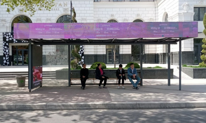
Competition Committee: Most bus stops across the country lack basic facilities
17:07
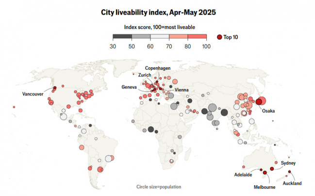
Copenhagen tops 2025 Global Livability Index, Tashkent near bottom

12:51 / 11.06.2025
AIIB to support road improvement projects in Uzbekistan

15:07 / 03.06.2025